A Nordic hop, skip and jump across to Tallinn

With Norway in our rear view mirror we were driving across Sweden heading for the Abisko National Park. We had been here before on a northern lights winter trip and it didn’t disappoint.

We stopped for a hike at Abisko and walked down to the lake shore (that we had walked across frozen in the winter) and then up the river. A beautiful place in all seasons.

We couldn’t stop for long though as our plan was to make it through the Nordics quickly so we could spend a bit more time in the Baltics.
As we headed south across Sweden we stopped for lunch at a really lovely beach on a lake. There were picnic tables and even free wood available for fires. Unfortunately the day we were there was not so sunny so we moved on and didn’t stay to enjoy the beach.
Just South of here we hit the Arctic Circle and stopped for the obligatory photo of the sign which we had missed on the way north in Norway because we were on the tiny coastal road.

Although we were heading through Sweden rather quickly we did make a detour to visit the Gammelstad church town. This is a Unesco site and is the best preserved example of a “church” town. These weren’t proper towns but instead were effectively towns of holiday homes clustered around a central church. People would trek from their actual homes to stay in their church town house at the weekend and for holidays. These towns are unique to Northern Scandinavia and exist because of the large parish sizes, inclement weather and laws requiring church attendance.

The town was still in use until the 1950’s and although some of the houses are still used for major religious holidays most are not. The houses did not have plumbing and each block has a central toilet for communal use.

After this interesting stop off we carried on driving and soon found ourselves in Finland.
The good weather had returned and our first Finnish stop was in a small regional park where we went for a walk through some woods – which were plagued by swarms of mosquitos – and had a lovely swim in a river which was fairly warm unlike the arctic swimming opportunities !

Finland is the land of lakes and forests and we found a couple of great places to stop for the night or longer if we weren’t beelining Helsinki and our ferry across to Latvia.
On arriving in Helsinki we found a car park just outside the centre and jumped on our bikes to explore as neither of us had been here before.

Helsinki is a fairly modern clean city which was really easy to cycle around. We made our way down to the harbour area and explored the little market there.

At one of the many food stalls we tried Vendace which are a lake fish that is similar to whitebait and is served lightly battered with lemon. Being seafood lovers this was right up our street and we weren’t disappointed.

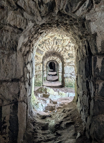
We took a ferry from the bustling harbour to Suomenlinna Fortress. This is a sea fortress built over 6 islands and 200 hectares by the Swedish in the 18th century, the primary purpose of which was to defend against the Russian Empire.

The fortress is vast and you can wander around the various islands for hours, accessing some of the buildings, seeing the big dry dock and the miles of walls.

Once we had our fill of the fortress we headed back to the ferry and across to Helsinki to pick up our bikes and carry on cycling around the city.

We stayed the night in the same car park that we had parked in all day because the next morning we had to be at the ferry terminal first thing for our crossing to Tallinn.

The ferry itself was massive and we were surprised at how busy it was, every single seat on board was taken. There was a long line of people outside the duty free shop, the corridors were packed and others just sat on the floor wherever they could find a space. We’ve never seen a ferry like it. It felt more like a party boat, with children’s entertainers, DJ’s and bingo!

The ferry takes around 2 hours and we soon arrived in Tallinn as the ferry terminal is really close to the old town. Conveniently there is a car park for motorhomes right next to the old town so we had no problems finding somewhere to park for our stopover.

The old town of Tallin is fairly compact and a great size for a weekend sightseeing trip.

The old town is a walled and cobbled medieval town with a big square in the middle. We stopped off for lunch at one of the restaurants near the central square and had our first taste of the famous black Baltic garlic bread, which is common to all of the Baltic countries. It is made with black rye bread and absolutely drenched in garlic butter. If you like garlic you will love this and we were to have it many times throughout our trip in this region.

During our stay in Tallin we also made time for two other stops. The first was the Seaplane harbour or Lennusadam which is a maritime museum. Here, in the massive hangars that used to house Seaplanes, is a fascinating museum, the highlight of which is a British built submarine called Lembit that you can explore inside.

Outside the hangar there are also a number of ships on the dock and in the water that you can explore including a 100 year old icebreaker with massive engines. You can go on board and walk around. The engines stretch most of the length of the ship and are three stories high.

The second place that we visited was Kadriog park which is centred around the Kadriog Palace, now an art museum. The park was built under the instruction of Peter the Great in 1718.

This was a great introduction for us to the Baltics. We loved Tallinn, there is plenty to do and see without feeling overwhelmed, which is sometimes the case with larger cities, great food and friendly people. You might want to leave the bikes at home though as the many cobbled streets make cycling around quite uncomfortable !
The North of Norway

After wending our way down and then back up the Lofoten Islands we eventually made our way onto the Vesteralen archipelago and the island of Langoya, the third biggest island in Norway.

We headed straight to the North of the island and down a pretty good unpaved road to the tiny town of Nyksund. This small fishing village was abandoned in the 1970’s but since 2003 it has seen a revival as a tourist destination, with a thriving restaurant scene (well 2 restaurants!) and around 30 inhabitants (in the summer).

The town has two rows of buildings separated by a waterway and a small protected harbour and we enjoyed mooching around the old derelict buildings from its old industrious days.

After visiting Nyksund we made our way back down the unpaved road and up to the Northern tip of Langoya and the town of Sto.

We’d come all the way to Sto for a whale watching trip that we had booked for the next day. Fortunately there was an abandoned campsite on one side of the Sto harbour which allowed us to spend the night within walking distance of the departure point for the boat tour.

The next morning at the harbour a lot of people appeared out of nowhere and in total about 60 people were loaded onto the whale watching boat. There was plenty of room in the boat’s cabin downstairs with airline style seating but as soon as we got going it became quite unpleasant as there was little air and some persistent swell so everyone relocated outside.

Up on deck there was seating for about 40 people and although Sarah was lucky enough to score a seat I was relegated to sitting in the elements on the bow of the boat which was the bounciest place.

We set off from Sto and headed Northwards towards the Bleik Canyon which is a feeding ground for sperm whales. Unfortunatley we weren’t lucky enough to see a sperm whale however it wasn’t too long after setting off that we saw some minke whales. These are sneaky whales, they only came to the surface briefly before diving back down so you had to be quick to see them.

It took us around 3 hours to reach the canyon and once here we spotted a big pod of pilot whales. We managed to have very good sightings of these small whales over the course of about an hour.

The swell calmed down in the afternoon and the water was much flatter than on the way out so the journey back in the sunshine was very pleasant. We also saw a Basking shark on the way back which is apparently a very rare sighting.

On the way back they served up an amazing fish soup made with locally caught fish. It was so delicious that we both had seconds.

The trip involves visiting the island of Anda which is close to Sto. We saw razorbills and puffins here but the highlight was a fairly large number of Sea Eagles which were both perched on the island and flying around.

It was a long day at sea, about 8 hours in total and we were surprisingly tired by the time we got back to shore so we decided to stay in Sto and have a down day, which was a good opportunity to get our laundry done – a service that was provided at the local café.

When we eventually left Sto we headed to the next door island, Andoya and drove to the Northern tip of this island where there is a ferry across to the island of Senja. We arrived at the ferry queue 2 hours before the departure time and were parked in lane 3 of 4 lanes. When the ferry was loaded only those in lanes 1 and 2 got on and the next ferry wasn’t until 9am, the next morning. We decided to move into lane 1 and spend the night in the queue as did many others, with those in cars heading off into town to find accommodation, leaving their cars in the queue. By 7pm that night lanes 1-3 were all full. This was the busiest ferry crossing that we had seen which wasn’t helped by the fact that it was also one of the smallest ferries.

Resigned to spending the night here we went into town to look around – although there wasn’t much to see. We did find a wine bar and sat down for a drink. This was the first time that we’d actually been to a bar in Norway and our concerns about the cost of the drinks was realised as a bottle of beer and a small glass of wine came to €20! Needless to say we did not stay for a second round.
In the morning we were pleased that we managed to get loaded onto the first ferry and watched from the back deck as a lot of the queuing vehicles failed to board. It is clear that this is a real bottleneck and if you decide to travel this way you need to leave plenty of time.
I can understand why lots of people want to go to Senja though. The drive across the island was absolutely spectacular as we drove around the fjords that split the island.

We stopped for the night in a beautiful valley, ooposite a highland valley with a waterfall cascading down from it.

The following day we started our drive across the island and stopped off at a small parking area next to the coast.

This was the the start of a short walk down a rocky coastline to some pools with amazing reflections of mountains across the bay. It was fun to clamber around the rocks to get the best angles.

The best know hike on Senja is the Heston hike where you get views of the foreboding Segla peak. This is a climb straight up from fjord side to a ridge with great views across to a jagged pyramidal mountain that towers over the fjord with a sheer drop.

Once you reach the top there are incredible 360 views of fjords and mountains. It’s a pretty easy hike and the payoff on reaching the top is amazing.

After the Heston hike we drove to the ferry to leave the island. Fortunately the queue for this was nothing like the queue to get onto the island and we easily made the first ferry. This carried us across to the mainland, near the city of Tromso.

Before hitting Tromso we stopped in at the island archipelago of Sommaroy, which in the sunshine looked more like it was in the Pacific than the Arctic. It was only a quick stopover as we couldn’t find anywhere to park for long. While here, we took the opportunity to stretch our legs on the beach but unwittingly disturbed a nesting bird. Sarah wisely backed away at its cries but I was a little slower to react and as a result was dive bombed repeatedly before it very accurately shat on my head, much to Sarah’s delight!

We arrived in the pretty town of Tromso on a lovely sunny day. It is definitely worth a visit although we were there only briefly. We managed to park in the downtown area and walked along the waterfront ticking off the main tourist sights.

The highlight of visiting Tromso for us were the botanical gardens. These are the largest Arctic Botanical gardens in the world and have arctic plants from around the globe. It was clearly a great time to go and many of the plants were in bloom.

After leaving Tromso we stopped briefly at the Arctic Cathedral which is a modern building. We didn’t want to pay to go inside so we only admired the architecture from the outside.

Tromso was the furthest North we were going on this trip and from here we started to head back south. We stopped off for a very windy night on the pretty Storfjord before getting up early the next day and heading to the trail head for the hike to the Steindalsbreen Glacier.

It was a grey overcast day when we arrived but the forecast was for gradual improvement so I set out on the hike to the glacier. This a fairly straightforward 7km hike, which takes you through forest alongside a river before climbing up and over the first moraine of the glacier. You then trek through a big glacial valley before climbing over another moraine and descending down to a glacial lake with a huge glacier tumbling into it.

There is only around 600m of climbing to get to the glacier but because it is pretty remote there aren’t many people on the hike. I hadn’t had any views of the glacier on the hike up because of the low cloud but as I arrived the clouds began to clear and I was rewarded with some great views.

This was a great hike to sign off our time in Norway but we had one more destination before driving inland and into Sweden and that was the town of Narvik.

Narvik is a modern town with not a lot to excite tourists. It does have a few museums and we choose (perhaps wrongly) to go to the car museum. This is not something I would recommend if you happen to visit the town. We did however enjoy a very good lunch at a fish restaurant (Fiskehallen), which was also fairly reasonably priced. The arctic char in particular was excellent.

From Narvik we started to drive East and after stopping for a night next to a beautiful mountain lake we entered Sweden and said goodbye to Norway after a fantastic couple of months (although the second half with sunshine was definitely better!).

Lofoten Islands and Sunshine

Travelling north from Bodo our first stop was Rago National Park, which has a fantastic hike to the Litlverivassfosen waterfall.

The hike to the glacier is a 13km long return and involves around 750m of elevation gain. The majority of the hike is through scrubby and boggy woodland but eventually you climb up a ladder out of a gully to the rim of a huge valley with a winding river at the bottom. As you move along the side of the valley a massive waterfall comes into view cascading down the side of the valley from a lake above.

The path continues down to the lake and across a bridge over the top of the waterfall. It’s possible to loop around but at this point I decided to retrace my steps. This is one of the most beautiful and dramatic valleys that I have been to and in my opinion, rivals Lake O’Hara in Canada – and that’s saying something.

From Rago we continued on our way north, stopping at Tommerneset, the site of some ancient rock art – which is practically invisible from the viewing spot across the river – and the longest Salmon ladder in Norway.

Finally we reached Bognes from where you can take a short ferry ride to Londingen on the Lofoten Islands. Unlike Bodo, there was no queue here and we were ushered straight onto the ferry.

On arrival, we drove a short distance to a lake side spot for the night and in the morning, we headed towards the small, sparsely populated fishing village of Laukvik. This is the site of some huge drying racks for stockfish (the local name for cod), where we found the racks covered in bundles of fish heads! Apparently, most of the dried cod that is produced in Norway is sent to Nigeria and is considered a delicacy in Nigerian cooking.

Our plan at this point was to drive the full length of the Lofoten islands to where the road ends at a town with the shortest possible name, A. We knew that better weather was forecast, so we were moving quite slowly as we wanted to see the dramatic scenery further south in good weather.

Before the good weather arrived though we had to occupy ourselves for yet another rainy day – so we went to the Lofotr Viking Museum (unfortunately it seemed everyone else had the same idea as the place was incredibly busy), where there is a re-creation of the longest long house ever discovered, only a few metres from the original ruin site.

A short walk downhill from the longhouse there is a small rebuilt viking boat which is sailed on a lake here. It moved surprisingly fast.

A bit further south from here are a pair of beautiful beaches on Vestvagoy, separated by a headland – with a tunnel through it of course. These were lovely in the low cloud and strong winds but I’m sure in good weather they are absolutely stunning.

We checked them both out and went for short walks down both beaches but the weather was definitely not conducive to sitting on the beach so we moved on.

We found a park-up with great views of some mountains across the sea, just down the road from the village of Vikten. It was a small layby at the side of the road but the road was a dead end and there was barely any traffic. While we were there the clouds started to clear and when we awoke the next day it was actually sunny !

We carried on South with a spring in our step – it’s amazing how a little sunshine can lift your spirits. We stopped off at a beautiful white sand beach called Ramberg beach, excitedly dug out the swim shorts and bathers from the back of the wardrobe and actually sat on the beach in the sun for a couple of hours soaking up some long awaited vitamin D. Sarah even decided to go for a swim until she put her foot in the water and beat a hasty retreat. Apparently it was, “flipping freezing!”

We stopped for lunch just down the road from Ramberg and I took the opportunity to send up the drone as the scenery was spectacular. The clear skies and sunshine had come just in time as we were entering the most dramatic landscapes of the Lofoten.

The next stop was Hamnoy, a small fishing village in a stunningly beautiful protected bay, with big mountains coming down to the water and the red timber buildings standing out against the deep blues of the water and greens of the land.

Also in this big bay is the small town of Sakriskoy, where we took a short break for a wander around.

In this stretch of the highway we were making slow progress as we were stopping to take in the views whenever we could find somewhere to pull over.

We finally made it all the way down to A and walked to the end of land (not really but the trail ends here). The town of A itself is very scenic and there are a number of museums presenting the history of the town and the fishing industry here.

Unfortunately there is nowhere to park overnight around A so we headed back the way we came (there is only one road through the Lofotens) and stopped off at the town of Reine where you can park at the harbour.

From here I did the Reinebringen hike which is an absolute killer. It is only just over 500m of climbing from the bottom at the coast to the peak, but it’s up a staircase with deep steps which is absolutely exhausting. I headed up confidently at first but had really slowed down towards the top and even took a couple of breaks before reaching the viewpoints. The views are spectacular though and well worth the pain of the ascent.

A little way North of Reine is the town of Nusfjord, which is actually a museum town. You have to pay an entrance fee to walk around the town itself but it was a fun detour and well worth the money. The car park for the town is very small though and we were lucky to find a spot for the camper.

In the early 20th century Nusfjord was an important fishing village and at its peak had over 500 fishing boats based here and 1,500 fishermen, but today it houses just 28 residents.

On our way South we had skipped the branch road that went to the town of Henningsvaer as we wanted to visit in good weather, mainly because I was keen to get a drone shot of its famous isolated football pitch on its own island !

The town itself is split by a channel and there is a small harbour at one end of the town. It’s a very scenic town which looks great from the air.
Henningsvaer was our last stop on the Lofoten islands as we were soon to be turning North to visit the islands of Langoya and Andoya.

We really enjoyed our visit to this amazing chain of islands. The scenery definitely did not disappoint and it is clear why so many people visit this area. It did feel close to being in danger of over tourism, the local population is low and the towns are very small, which means that they can be easily overrun and I wonder how the locals feel about this annual summer influx. On the plus side, the weather itself must help to restrict this to only a few months of the year.

Fortunately there is no major port on any of the islands only small fishing harbours so the cruise ships that were so common further south cannot come into this area.

For those of you like us, who want to visit the Lofoten by motorhome, there aren’t that many campsites and the ones that we saw seemed to be very busy. However we didn’t have any problems finding wild camping spots for the night, although we would start to look for a place relatively early, around 4pm. If you do wild camp, there seem to be fewer motorhome services dotted around than on the rest of Norway but there are still enough to get by if you plan well.

Norway’s West Coast

After leaving Alesund we took the marine highway up the West coast of Norway. This route involves a lot of ferries but fortunately the less used ones are free as they are subsidised by the government.
We were heading up towards the Lofoten islands, planning to drive onto them from the mainland rather than take the ferry from Bodo, which we had heard could involve a substantial wait.
However, first we needed to do some laundry so we headed to a pretty lakeside campsite on the next peninsula along from where we were. The weather wasn’t great so no swimming or kayaking but we enjoyed a day off and a managed to get our clothes washed and dried.

A short drive from the campsite is the trail head for the Troll Church or TrollKirke hike. This is a great hike which heads up into the hills. At the end of the hike are three caves that can be entered – although you need to bring a light.

The first cave is the biggest. Here a long narrow tunnel with a small river leads through into a large chamber which is open to the sky and within which, a waterfall plunges down from the cave above.
The exit from this cave is a climb up just before the chamber and requires a little climbing experience.

Once out you can enter the second cave from which the waterfall comes. This is much smaller and has another smaller waterfall inside it.

These two caves are the main ones that people visit however there is another one up above. A five minute hike takes you to a plateau above and after a bit of searching you can find a small hole down into the ground. This is the entrance to the third cave which has a small underground river in it. The main passage is around 20m long but gets lower and lower as you progress – I stopped before I was crawling in the water!
This was a great fun hike with something a bit different at the end.
Our next stop was at what is considered to be one of the most scenic drives in Norway. The Atlantic Ocean Road is a 5 mile long series of islands connected by bridges and causeways to create a road across the mouth of a fjord.

We didn’t do the drive in the best of weather but it is over very quickly and there are definitely much better drives in Norway.

Shortly after the Atlantic Ocean Road we stopped off at Kristiansund which is a port city. There is an interesting historic port area, which has been kept exactly as it was, including a big workshop that still has a forge and all the original tools. This was fascinating to wander around.
Next on the trip was the city of Trondheim, the third biggest city in Norway but with a population of less than 250,000.

We found a great place to stay just outside the city by a lake that was popular with runners and walkers. While we were staying there we had a bit of drama as a large bin caught fire. The fire brigade arrived and promptly put it out. The full breathing apparatus seemed a bit overkill !

The city of Trondheim itself is quite compact and is easy to see in a day. We visited the Kristiansten fortress and museum, which sits on a hill overlooking the old town with its famous Old Town Bridge that crosses the Nidelva river.

We also enjoyed a wander around the very impressive (inside and out) Nidaros Cathedral. The cathedral was built on the burial site of King Olav II who died in 1030 and is the typical location for the inauguration of Norwegian Monarchs.

The highlight of our visit however, was a tour of Stiftsgarden, the official royal residence in Trondheim. The palace was built in the 1770’s and was the main setting for the celebrations of the coronations of Norwegian monarchs up until 1906.

As royal palaces go it was definitely less ornate and lavish than most that we have seen in Europe and reflects the relative poverty of the Norwegians in this time as the country had been hit extremely hard by the black death and took centuries to recover.

After Trondheim we carried on heading North to the island of Torget which is connected to the mainland by a bridge. This is the home of The Torghatten granite dome which is well known for the big natural tunnel that goes through it. There is a short hike up into the tunnel and down the other side. The tunnel itself is 35 metres high and 160 metres long.

Torget was a stepping stone for us as we caught the ferry from here across to the island of Vega. This is a beautiful and sparsely populated island.

We drove round the island stopping first at the visitor centre, whose boardwalk was being guarded by several very large horned goats that we edged ourselves nervously past, before then visiting the Vega Stairs (vegatrappa).

This is a staircase of almost 2000 steps to the top of Ravnfloget, offering beautiful views across the Northern coast of the island and across to the mountain island of Sola.

We managed to find a lovely spot for the night on the Western shore of the island before taking another ferry heading North to the island of Tjotta and back onto the road network, before very quickly needing another ferry taking us to Alsta, where the seven sisters mountain range stretches across the length of the island.

The hike up the mountain was thwarted by the weather and I eventually stopped before reaching the top as it was shrouded in thick cloud.

From Alsta we carried on moving North via bridges and ferries. There were no real highlights to the route but it was a very scenic drive and we stopped at some lovely spots for the night. The overcrowded south seemed a long way away as this part of the country is definitely not as heavily touristed. Most people stick to the main highway and shoot North to get to the Lofoten islands.
There was one real highlight though as we got closer to Bodo which is the Svartisen glacier. This is visible from the highway although to get to the trail head you have to get a ferry 15 minutes across a fjord and then to avoid a 4km boring walk you can hire a bike to the start of the hiking trail to the glacier.

From here it is a hike (pretty steep in parts) up the terminal moraine of the glacier. The trail is well marked and takes you to a viewpoint about 400m from the glacier. From here it’s possible to strike across the rocky terrain and make it right to the front of the glacier.

The views from the top of the moraine are great and it’s certainly a more impressive glacier than those that we had visited further south.

As you drive North from the glacier a long tunnel takes you through the mountainside and to a different fjord. From here there are roads that run up into the mountains and to two big dammed mountain lakes – the Holmvasdammen and the Storglomvassdammen.

We visited both – travelling through a 1km, single lane pitch black rough hewn tunnel that was something of an adventure. We couldn’t quite drive to either as despite being July there was still thick snow lying on the road – but we could get within walking distance.

The views across the snowy frozen landscape were great and well worth the challenging drive to get up here.

Back down the mountain there was no sign of the snow and beautiful wild orchids grew around a lake where we spent the night.

After exploring the mountains we headed back to the coast and carried on northward coming to the bridge over the Saltstraumen which is a narrow strait with one of the strongest tidal flows in the world reaching up to 20 knots. We timed our visit with an incoming tide and although you can definitely see the strength of the current from the bridge above, it’s not the most spectacular show.

This was our last stop before reaching Bodo, the gateway to the Lofoten islands. We drove through the town and passed the lengthy ferry queue, as most people take a ferry from here to the end of the Lofotens islands. However, we had decided to drive around to get to the Lofotens so we still had a little way to go.
First up though we headed to the pretty island of Kjerringjoy, a popular weekend jaunt for the locals but not many tourists. There wasn’t much to see on the island except lots of lovely coastline and one of our favourite park-ups of this trip – a large grassy area on a beach with a pair of nesting sea eagles on the cliff opposite us. Finally the sun blessed us with its appearance and we enjoyed our first BBQ of the trip after over one month on the road.

Fjords, snowy landscapes and glaciers

After parking in one of the big lots right next to Bergen airport we boarded our plane for Palma, Majorca via Oslo. It was all very straightforward flying with Norwegian Air and the views over the Fjords were spectacular.

On landing in Majorca it felt like summer had finally arrived as we moved from a cold and grey 12 degrees in Bergen to 30 degrees and blue skies in Majorca. This was a very welcome improvement.
We had a bit of time on our hands before everyone arrived so rather than jump in a taxi, we decided to take the bus instead, to Port de Soller, where we were meeting up with some friends. This proved easy enough and took just over an hour.
After leaving the bus it was only a short walk to the harbour where two of our friends were waiting for us, already happily ensconced in a bar. And that is exactly where we stayed until we were al kicked out at closing time. Two more friends had arrived in the meantime and one or two drinks may have been consumed!

We had a lovely long weekend sailing around the coast back to Palma with this motley crew and with the beautiful weather it really felt like a proper holiday.

Unfortunately all good things must come to an end and waving our friends goodbye, we flew back to Bergen via Oslo. In our absence the weather had not improved and we returned late at night to a very cold and wet Norway.

We found somewhere to park-up for the night and, due to more heavy rain the next day, we skipped visiting Bergen itself and drove until we reached Gudvangen, a beautiful valley with many waterfalls pouring down the sides (this much rainfall has its benefits). It rained continuously for two days so we just hunkered down and caught up on some lost sleep from our weekend away.

There is a popular tourist ferry from here, down a narrow fjord to the small town of Undredal, although we decided to drive there instead. It really is a tiny town with just a small church and a smattering of buildings but it’s very pretty and when we arrived first thing in the morning there was almost no one around.

At the end of the Fjord from here is the town of Flam, which is a very popular tourist stop. It is mentioned in our Lonely Planet guide as a must stop. The reality seemed a little different. It’s a tiny town and when we arrived there was a massive cruise ship moored alongside it, dwarfing the town and on the dock were hundreds of cruise ship passengers. We left pretty sharpish as this really wasn’t what we were looking for.
The obvious way to leave Flam is to go through the Laerdal tunnel which is the longest road tunnel in the world at 24.5 kms. However we decided to take the scenic route via the old road which goes over a pass in the mountains instead.

The first stop – which again is a very popular spot with the cruise ship passengers – is the Stegastein viewpoint, where a modern platform has been built off the side of the mountain to give amazing views of the Fjord below.
Thankfully it isn’t long until you leave the crowds behind. As we climbed further up into the highlands the temperature continued to drop. We had debated staying overnight in the mountains but with a daytime temperature of 3C we weren’t keen on finding out what it would drop down to over night, so we rapidly moved on.

It was mid June by this stage of our trip but we’d yet to see any sign of summer in Norway. There was still plenty of snow in evidence and the lakes were still partially frozen. We don’t know if Summer comes late here or if this year the weather has been particularly bad but despite this, it is an undeniably beautiful landscape.
We took in a few sights as we made our way across the top. There was a very pretty walk across the tundra to a lake and waterfall at Flotane, where we also saw a couple of Norwegian Lemmings scurrying around (no picture though as they were too small and fast for us).

There is also a modern art installation along this route in a man-made cave – a bear on a rubbish heap, which is said to explore man’s impact on nature over time.

After dropping back down to Fjord level we found a nice place (albeit by the side of the road) to spend the night, looking out over the water. This was the first place we had stayed the night in Norway with a lovely view. The park-ups had not been living up to our expectations so far but things definitely improved the further North we went.

Having skipped the Laerdal tunnel to go over the mountains we arrived back down in Laerdal, which is a very pretty historic town. We visited early in the morning before any of the cruise ship passengers managed to make their way there.

Just down the road from Laerdal is the Borgund Stave Church which is the biggest and best preserved of all the stave churches. The entrance fee to the church also includes the museum, which is informative and well worth a look.

Next up we drove over another mountain pass road – The Tindevegen road which then goes into the Sognefjorden scenic road (you can find all of Norway’s scenic routes on the VisitNorway website). This took us across to the little town of Lom and another Stave Church.

We spent the night wild camping near here next to a very loud fast flowing river. The amount of rain we’ve had means that all the rivers are currently raging torrents.

Up early the next morning we drove the absolutely beautiful (and unpronounceable) Gamle Strynefjellsvegen scenic route over another mountain pass. This one was shrouded in cloud but probably the snowiest and most scenic of all the ones that we have done so far.

Once across the mountains where we had been mostly alone and blissfully free of all the crowds, we arrived back in another one of Norway’s heavily touristed areas, where the glaciers sweep down from the ice sheets.
We drove up one of the valleys that has a glacier at its head, the Kjendalbreen glacier. The last few km’s of road are a toll road that gets pretty narrow and a bit rough but you end up in a gravel car park that is only around 400m to the glacier viewpoint.

You can actually walk further along the valley but it gets pretty rough going as you have to walk along the very rocky river bed.

Retracing our steps back through the valley we drove south to the next valley and immediately knew this would be busier as we passed a cruise ship and saw a whole bunch of coaches ferrying passengers up the valley.
There is a big car park at the head of the valley but this glacier – the Briksdalbreen glacier – is a bit of hike, around 2.5km with 200m of ascent.

However, if you don’t want to walk you can take a ‘troll car’ up the road to the glacial lake although it’s a little pricey.

On the hike up you pass a huge waterfall and then eventually arrive at the moraine lake at the foot of the glacier. Unlike the last one, you can’t really get close to this glacier, but you do get some very good views. I actually realised on arriving at the lake that we had been here before when we spent a long weekend in Bergen 15 years ago!

We spent the night in the Briksdalbreen car park and the next morning set off early for the ferry dock at Helleslyt. This ferry is not a normal one that is part of the highway system but is instead a tourist ferry that has seats out on the deck and a commentary. It’s a bit expensive at approximately £80 but we decided to splash out.
The ferry traverses the famous Geirangerfjord which is a very narrow Fjord with lots of waterfalls cascading down the sides. Most famous of which is the seven sisters.

The most interesting parts of the ferry ride were seeing the abandoned farms that were perched on the nearly vertical valley sides. The slopes were so treacherous that their kids used to be tied by rope to the houses when they played to stop them falling into the Fjord. Despite the steep cliffs these farms used to produce potatoes, cabbage and carrots.

Once we got to the end of the ferry ride in Geiranger it was very busy. There were two big cruise ships docked and we immediately left town and joined the slow-moving traffic switch-backing up the mountainside. There is a viewpoint of the fjord on the way but it was so busy we couldn’t park, however the traffic was so bad that I managed to jump out, take some pictures and get back in while Sarah drove slowly past.

The road goes over a mountain pass and fortunately most of the traffic turns back after the viewpoint so it became much quieter. We were heading for a very famous Norwegian road called Trollstigen which switchbacks down from the mountains.
Unfortunately at the time we were there the road was closed as a result of landslides caused by melting snow.

We were however able to drive the 30kms to the viewpoint over Trollstigen, which has a fantastic view of the switchbacks and the valley below towards the town of Andalsnes.

As we drove back along the quiet road we stopped in a big mountain valley for the night. It was our best wild camping spot in Norway so far with amazing views up and down the valley and a huge waterfall across the valley from us. It was a cold but beautiful evening and for perhaps the first time in Norway we were actually alone for the night.

Getting back around to Andalsnes was a bit of a long trek with the pass road closed so we decided to head to Alesund as our a next city stop.
Alesund is a city which is spread out on number of islands at the mouth of Geirangerfjord. It was destroyed by fire in 1904 and when they rebuilt the city after that it was with a consistent Art Nouveau style.

We wandered round the town with no real purpose, although Sarah visited the Art Nouveau Centre, which told the story of the town fire and reconstruction very well via a ‘time-machine’ and film, and the KUBE contemporary art museum while I climbed the 418 steps up the hill overlooking the town to get a view across the islands.

A short drive away, on the outskirts of the town is the Sunnmore museum. This is mainly an outdoor museum with lots of examples of traditional buildings from the history of the region, spanning medieval times up to WW2.

There are also some boat halls which have a range of historic fishing boats used in the region from Viking times up to the 20th century. The most interesting is probably a Viking boat from 780 AD. It’s about 18m long and was found in a marsh which helped to preserve its wooden structure.

Exploring South West Norway

Norway had been a destination that we were keen to get to ever since we started travelling in our Motorhome. We had spent a long weekend there over 10 years ago and knew how beautiful the scenery was but also how brutally expensive eating out is.
There was some socialising to do though before leaving home, my rugby clubs annual dinner. It was a great evening and I enjoyed speaking with Neil Back, from the England 2003 world cup winning side, as well as catching up with lots of friends.

So it was with a slight hangover the next morning that we started our journey to Calais via our usual stopover at the Canterbury Aire, enabling us to get an early morning ferry. We arrived in France early the next day and, as we wanted to make the most of our 90 days in the Schengen zone, we started to make the long drive North towards Denmark, only stopping for some shopping at a French hypermarket on the way.
Our plan was to make it to Hirtshals at the Northern tip of Denmark in just 2 days. This is where the ferry across to Kristiansand in Norway leaves from and is a journey of almost 1,300kms.

Our first stop was in Bremen in Germany where we found a small car park in a lovely wooded area to spend the night and making it to the small town of Hjorring in Denmark where we spent the second night at a lovely park-up right on the beach. The weather wasn’t great (which was to be the norm for the next four weeks), but we still managed to get out for a walk along the beach.

The next morning we were up early to get to the ferry dock in Hirtshals where we boarded the large ferry for the 3 hour trip across to Norway. The ferry was busy (with a vast number of motorhomes in the queue), but we managed to find somewhere to sit in the bar area – not actually open during the morning crossing – and before we knew It we were docking in Norway.
Arrival in Norway is just like arrival at Calais, there are no formalities or checks, you just drive straight off and get on your way.

We had decided to spend our first night at the very popular Lindesnes lighthouse. We knew Norway would be busy with motorhomes but we were still shocked by just how busy it was at the beginning of June, with 40+ motorhomes parked up there for the night.
The car park was a pay spot but it included a ticket to see the lighthouse and museum.

It was a nice spot for a first night in Norway and in the morning I went for a hike around the peninsula and along the coast.

After having a good look around we left here and visited Kvasfossen, one of many waterfalls that we would see in Norway.
Our initial plan was to head up the coast towards Stavenger and we drove round our first of many Norweigan Fjords. This was Jossingfjord where there are two small houses built under a cliff overhang for protection. These houses were built in the early 19th century and were occupied until the 1920’s. They were the houses of poor families who made their living from a mixture of farming, sheep herding and fishing.

We carried on up the coast from here, intending to hike to the infamous Trollpiken Rock, but incessant heavy rain put paid to that plan.

However the weather improved for our visit to Stavenger the next day. Stavenger is a lovely little port city and well worth a stopover. We were also lucky that on the day we visited, a festival was taking place around the harbour, with live bands, demonstrations of smithing and some historic boats that were open to the public.

We dragged ourselves away from the buzzy dockside area to also visit the cathedral with its impressive pulpit, the brightly coloured Fargegaten Street and the very pretty historic old town (Gamle Stavenger), where all the houses are painted a uniform white.

After a rejuvenating but pricey hot chocolate and slice of cake we took a short drive outside of town to visit the Swords in the Stone or Sver I Kjell. This is an impressive sculpture of three enormous swords sunk into the rock overlooking the sea, as a tribute to the Battle of Hafrsfjord in 872 where King Harald Fairhair unified Norway.

We couldn’t hand around in this area too long as we needed to be in Bergen in one week for a planned trip. So we kept moving North but of course had to stop to do the well known Preikestolen hike. This is more commonly known as Pulpit Rock and is one of the most famous walks in Norway.

It is also one of the busiest so we found somewhere to spend the night nearby and aimed to get to the car park as soon as it opened – which was 6.30am.
This paid off for us, as not only did it start to get very busy later on but the best of the days weather was early in the day. It’s not a particularly hard hike with Pulpit Rock being only around 4km from the trailhead, but there are three steep climbs totalling about 400m of elevation.

Once you get to the rock itself, in my opinion this gives you the worst view. It is much better to climb up a little further and get the view looking down onto it, although surprisingly very few people seemed to do this.
After leaving Pulpit Rock we soon came upon our first Norwegian ferry of the trip. This was right next door to a giant red chair (I don’t know why).

The ferries are very easy to navigate as you just drive straight on board. We had arranged for an electronic tag before we left home that automatically deals with all Norwegian road tolls and ferries – you even get a 50% discount on ferries. We used Flyt but there are others, collectively known as Autopass.no. The only downside is that they invoice you monthly and you have to pay by bank transfer – which for us means an additional £5 bank charge but you factor this into the savings you make.
The ferries and tolls individually aren’t that expensive but there are a lot of them and they add up. Fortunately as you get further North more of the ferries are free as they don’t get used by enough people per year. Tunnels often come with tolls in Norway but once the building costs are paid off they become free. There are a lot of tunnels in Norway too, from the roughly hewn unlit ones in more remote locations to ones with coloured lights and even roundabouts and junctions inside them. The longest tunnel in Norway stretches for 24.5kms!
Once you begin to get close to Bergen you enter the Fjordland region of Norway. This means lots of rain and while we were there, cold conditions. The temperature was only averaging about 12c each day. A bit chillier than we were expecting for this time of year but luckily we had packed a few jumpers as well as our rain gear.
The rain and the Fjords amount to a lot – and I mean A LOT – of waterfalls. It gets to the point where you ignore all but the most scenic of them, which for me is something new as I love a waterfall.

As we headed North we came to one of the most impressive and biggest waterfalls in Norway – Langfoss. This has a total height of 612m and the road actually runs across the bottom of it before it finally reaches the Fjord. CNN has actually named it one of the top ten waterfalls in the world, although its easy accessibility probably has something to do with that.
A less common sight but definitely worth looking around when you come across one, are the Stave churches. In North Western Europe, there used to be hundreds of Stave churches, which are built using a particular type of timber framing, but nowadays only 28 have survived in Norway and only 1 outside of Norway. They are generally over 800 years old but the pitch used to protect the wood unfortunately makes them very susceptible to fire!

Our first visit to a Stave church was to Roldal, which was built in the 13th century and restored in the early 1900’s. Roldal was one of the most important sites for pilgrimages in Norway.

Before arriving in Bergen, the last major town we went through was Odda. This happens to be the nearest town for another famous hike, the Trolltunga or troll tongue walk. I had wanted to do this but after some research on parking fees and costs of the shuttle buses etc., it was going to cost around £80 to do a hike, which seemed excessive to me, so we decided to pick another hike in the area.

After staying the night in a very small car park which was absolutely packed with motorhomes and vans, we got up early the next morning and drove to the trail head for the Buarbreen Glacier hike. This is an out and back hike of only 5km with a 400m vertical. The hike is a little tricky with some ladders and chains in the latter part but nothing to scary. There aren’t many views on the way there but the payoff is at the end when you see the glacier falling off the ice sheet above. Thankfully, the weather held off and gave me some good views of the ice.

After finishing the hike it was onwards to Bergen, continuing past more epic waterfalls.

The first of which was Latefoss, which thunders down right beside and then underneath the road and secondly, Espelandfossen. They are located very close together with only a tiny parking area but with a little patience and a bit of driving back and forth we eventually got ourselves a spot.

The next waterfall was Steindalsfossen, which is pretty cool as you can walk behind it (also note the old stone bridge leading up to it), and grab yourself a very nice ice-cream from the little on-site café.

And lastly, there was Fossenbratte waterfall. This is a bit of a walk down from the road but if you are a waterfall fan, definitely worth it.

From here, as you approach Bergen, the surroundings start to get more built up but we managed to find a lovely peaceful park-up in the suburbs, on a cute little harbour right next to Bergen Botanical Gardens which are roam around. In fact, this was only a 10 minute drive from the airport so perfect for our flight the next day.

Inbetween Travels

After returning from Africa we had a couple of months in the UK before again heading off overseas, which gave us plenty of time to MOT and Service the Beastlet. Unfortunately it was more pricey than usual this year as the camper is now five years old, which meant it was time to replace the timing belt and water pump. This isn’t one to ignore as a failed timing belt destroys the engine.

Being home is also a great opportunity to catch up with friends and family so we inevitably spend a lot of time socialising and eating and drinking in pubs and restaurants.

The campsite where we stay in Surrey is ideally situated for us while visiting friends and family and, as an added bonus, this Spring, a pair of Geese hatched a large brood of gorgeous fluffy goslings that they were happily parading around the campsite. They looked like something right out of an Easter cartoon !

In addition, there are some beautiful bluebell woods around Surrey so we visited a few, making the most of the unusually warm Spring weather before deciding to spend a few weeks touring Wales.

Sarah, despite being a proud Welsh girl, had never actually been to North Wales so as well as showing me some of her favourite places in South West Wales there would be plenty of new places for her to explore as well.
Our first stop though was to visit friends in Cardiff and after a very boozy, fun weekend we headed West towards the coast. Our plan was to stick to the coast as we headed North and then circle back down South via the East of England.

First stop was one of Sarah’s favourites, the town of Tenby, where we stayed in a nice campsite above the town, about a 15 minute walk to the centre. The main irritant (to us) with touring in the UK is that it is pretty difficult to wild camp and there are very few aires so most of the time you have to stay in campsites which get very busy, especially at weekends. Prices of course vary but on average we were paying between £25-£28 a night (excluding electricity), although note that many of the campsites in Wales also charge extra for using the showers?!!

Tenby can get very crowded in the summer but at this time of year the beaches were quiet despite the unseasonably warm weather and we had a lovely time wandering through the streets sampling the different bakeries and taking in the sights.

Just offshore from Tenby is a small island called Caldey Island which is owned by monks who have a large monastery there. Besides the monastery and church not far from the boat dock, the island is mostly agricultural and it is possible to do some nice walks around the island while enjoying some of their home-made chocolate!

After two days in Tenby (definitely not long enough), we left early the next morning as we had booked a boat trip to Skomer Island to see the Puffins. You have to book way in advance to get a space and even then we couldn’t get a place on the first ferry over. If you are heading there in a motorhome be aware that the road to the boat dock gets very narrow in the last few kilometres but there is parking when you arrive – just hope you don’t meet any oncoming traffic.

The journey over to Skomer only takes 15 minutes and you get dropped off at a small pier at the foot of a cliff. The climb up to the island itself (using steps and a path), only takes a few minutes and you will definitely see your first puffins on the way up as well as Guillemots and Razorbills that are nesting along the cliffs.

Once you have climbed to the top of the steps there is a short talk by one of the islands volunteers about the island and the regulations governing your interaction with the wildlife. The island of Skomer is a nature reserve and is most famous for having the biggest colony of puffins in Southern Britain and indeed one of the biggest in the world.

This year the annual puffin count was around 40,000. Not surprisingly we started seeing puffins straight away and their burrows were dotted all around the path.

Skomer is much more than just Puffins though and the trip to the island that gives you five hours to explore doesn’t feel like nearly long enough. The island has lots of birdlife, including short-eared owls (although we didn’t see any), seals and lots of cute little bunnies scampering about. The walk around the island is around 6.5km and is gorgeous at this time of year with wildflowers carpeting the landscape.

The puffins are of course the highlight and in certain places there are lots of them right next to the path. We saw them coming and going to their shallow burrows but it was still too early in the year for chicks.

It was much trickier to get a good shot of the Razorbills and Guillemots as they were nesting right on the cliff edges.

Before arriving, we were dubious as to how we would fill five hours on a small island but in fact, the time flew by and we found ourselves having to hot-foot it back to the pier for our allotted return boat.

We had planned to stay in a campsite right next to the Skomer boat car park but decided that we would rather do the narrow road out later in the day when all the traffic is going in the same direction, rather than the following morning. So we headed off straight away and ended up spending the night in a very nice campsite called Glan y Mor in St. David’s.
This wasn’t far from the beach and there was a nice clifftop walk to St. Non’s Chapel and well (St. Non was St. David’s mother).

The next day we continued our drive North, first stopping at the Blue Lagoon at Abereiddi – a former quarry right on the coast. I’ve lost count of the number of Blue lagoons that we have visited in various countries !

From here we carried on up the coast to the former industrial port of Porthgain. This tiny pretty inlet has a harbour which used to ship quarried and prepared slate around the country, some from the Blue Lagoon we had just visited. Eventually the slate stopped being shipped and it became a centre for brickmaking but after the 1930’s it was abandoned.

We finished the day at a lovely cliff-top campsite in Mwnt, Cardigan Bay with fantastic views of the coast and the tiny 13th century Holy Cross church. We spent a couple of days relaxing here, enjoying the sunny weather, which we had continued to be blessed with, and visiting the lovely Mwnt beach.

Our next destination was somewhere that Sarah had been wanting to visit for years, Portmeirion.

Portmeirion is famous as the shooting location for the surreal TV series the Prisoner in the 1960’s. However, it was actually built as a folly by Sir Clough Williams-Ellis between 1925 and 1975. It is now run as a hotel and tourist site. It is a weirdly wonderful place that feels more Mediterranean than Welsh and I don’t think there is anything else like it in the world.

There is actually a motorhome aire on-site (with excellent facilities) so you can stay overnight in a camper. Just like a hotel guest, this gives you access to the site once all the tourists have gone home both in the evening and before they arrive in the morning as well as use of the heated outdoor pool and beach towels. With your entrance included it is actually pretty good value and we had a great time wandering around.

From Portmeirion we headed to Porthdinllaen on the Lynn Peninsula where we of course had to visit the famous Ty Coch pub which sits right on the beach in a pretty little cove just a short walk across a golf course from our campsite. We enjoyed a few beers sitting on the wall outside the pub with our feet dangling over the sand, watching the local fishermen land and tow away their fishing boats across the beach.

This area also had a really nice coastal walk that goes out to a coastal watch station and then along the beach to the village of Morfa Nefyn and then back to the campsite at Porthdinllaen.

While Sarah had always wanted to visit Portmeirion I had always wanted to see Caernarfon Castle and this was our next stop. It’s a big castle and takes a couple of hours to explore with interesting exhibits and numerous towers to climb to get different perspectives on it. This 11th century castle is a UNESCO World Heritage site and was used for the investiture of the Princes of Wales in 1911 and 1969.

Next up on our Welsh tour was the island of Anglesey where we visited Plas Nedwydd House, most famously the home of the 2nd Earl of Uxbridge who was a hero of the battle of Waterloo as second in command to the Duke of Wellington. He actually lost a leg at the end of the battle after leading a cavalry charge. He was fitted with an artificial leg and they became known as Anglesey legs after his other title of Marquess of Anglesey. The house is quite grand and the gardens are lovely – well worth a visit if in the area.

While on Anglesey we also visited Beaumaris Castle which was designed as a very grand castle indeed but never actually finished as rebellions in Scotland took money away from the budget to build it in the 1320’s as King Edward I switched his attention to Scotland.

Unfortunately we were running out of time, so that was it for us on Anglesey but we had seen enough to know that it was somewhere we would come back to explore in the future.

Our last stop in Wales was the pretty town of Conwy, which is dominated by a huge castle that used to have the main road run straight through it. The road has been moved – and is now a much bigger highway.

The castle was again one of King Edward I castles and was built very quickly, in just 4 years, in 1283. The castle is split into two parts with the inner royal section having been a luxurious living and entertainment space. It’s another great castle to visit with fantastic views.
The town of Conwy itself is a waterfront town with a tidal harbour wall. When the tide is out it looks as though the boats resting on the sand will never be able to sail away but the tide comes in fast and suddenly they are floating high against the wall.

We took a walk through the town, stopping off for some fish and chips and visiting the smallest house in Britain. It was absolutely tiny and bizarrely the last owner had been 6’ 4” – how he fit I don’t know.

After visiting the town we drove the short distance to Bodnant Gardens which are well worth a visit especially if you are National Trust members. There are lots of different gardens, woods and meadows to explore not to mention the Instagrammers favourite, the Laburnum Arch.

And with that, we had come to the end of our quick tour around the coast of Wales, feeling incredibly lucky that the sun had stuck with us throughout the trip. Needless to say we will definitely be back as there is so much more to see.
We weren’t due to go home yet though, as we were heading to North East England to visit our friends the Roverlanders, who we had met in Serbia last year. They are completely refurbishing their Landrover ambulance conversion, so they’ve rented a house to be their base for doing this.

On the way over to them we stopped off at Chester. The town was pretty disrupted as there was a half-marathon taking place so much of it was roped off. We did however manage to get in and see the very impressive cathedral and have the best Bakewell tart EVER at a lovely little cafe called Huxley’s next to the clocktower.

After spending a couple of days with Donna and Jon, The Roverlanders, where we visited Whitby together and enjoyed some delicious fish and chips we headed back South and our little UK excursion was over.

With just a week in London we were then heading off for our summer trip to Norway.
Kenya

Kenya is the first destination of our trip and the first time in years, that we had put ourselves in the hands of a tour company. So when we arrived at the airport we actually had a pickup to take us to our hotel in the Nairobi city centre.

The tour company didn’t get off to a great start as despite knowing when we were arriving the pickup was an hour late. Anyway, in the meantime we managed to secure the usual essentials easily enough at the airport – a sim card and local currency.
We arrived at our hotel which was a bit unusual as the entrance was through a small shopping mall but the security guard at the entrance was very helpful and pointed us to a lift which went up to the hotel.
We had a day to spare before our tour began so we did a little exploring around our hotel and found a restaurant for lunch but we weren’t up for much as we knew the tour was starting early the next day and would be very full on.
In the morning we were picked up by Wilson, our Masaai guide for the week. The vehicle for the trip was a Toyota Landcruiser with three rows of seats and a raising safari roof.
We visited a few more hotels to pick up other guests for the trip and were surprised that the Landcruiser would be completely full.

Once we had collected everyone we started to drive out of Nairobi and head towards the Masai Mara which is about a four hour drive from the city. We stopped off at a viewpoint to see the Great Rift Valley but visibility wasn’t great – we still managed to get a sense of the size of the valley but it was very hazy.

After this it was back in the car and the last hour of the drive got very bumpy as we headed down an unpaved road towards the Southern gate of the Masai Mara. We travelled at a fair pace and after the biggest bumps a musical “Sorry” would ring out from Wilson in the front although the pace didn’t slow.

Eventually we reached the Masai Camp hotel, which was only a few hundred metres from the edge of the Masai Mara. After being welcomed by the Masai staff in their colourful traditional dress we dumped our bags in our tents (despite being tents they still had an ensuite bathroom) and headed back to the Landcruiser for an evening game drive.

It didn’t take long once we were in the park to start seeing wildlife. The first area we went through had the grass cut back and we had great sightings of eland, buffalo, warthog and of course impala.

This abundance of wildlife was to be a theme of the Masai Mara and we would seldom go long without a new sighting.

The highlight of this evening game drive was a pride of lions atop a big mound of dirt, which was giving them a panoramic view of the surrounding area, including a delicious looking herd of buffalo! When we first arrived at the lion sighting we couldn’t get very close as the road was closed, so we were, along with a few other vehicles, kept at a distance. However when we returned almost an hour later the road block had been lifted and a group of park rangers were monitoring access to the area.

This was the start of witnessing the slightly strange approach to off-roading that exists in the Masai Mara, which is unlike anything we have seen in any other game park. Off-roading is not allowed – unless there is a predator sighting, then no more than five vehicles can go off-road to see the animals before having to return to the road. There are big fines for breaking these rules and we saw lots of Rangers who were doing their best to manage the process but when there is no ranger vehicle in sight it’s a bit of a free for all as the guides attempt to get the best viewings for their guests.

The off-roading rule is not the only way the rules get broken in the Masai Mara. We spent some time with the pride of lions and our guide agreed to let us stay to watch the sunsetting behind them, but we were a fair distance from the exit which meant we wouldn’t make it back before the park gates closed at 6.30pm. No problem though, we eventually left the park by a back road around 7.30pm in almost total darkness. Hakuna Matata, as they like to say in this part of the world.

We went back to the Masai camp for an evening meal and learnt quickly that they were feeders. It was a three course meal and there was loads of food. If you didn’t clear your plate then they would jokingly push you to eat more. The food was great though, very tasty. After leaving the main building at night to go back to our tent we were escorted by rangers as predators have been known to wander into the camp but to our relief, the only wildlife we saw on the way back to our tent was a small herd of zebra grazing.

The next morning we were up early as we had a full day game drive in the Masai Mara on the plan. This was to prove a long day as we started early and didn’t get back to the hotel until gone dark again.

This was by far the best single days game drive that we have ever done. We had multiple lion sightings and even saw our first full grown male lion. We saw a cheetah and a couple of leopards as well as the full gamut of prey animals, not forgetting of course the elephants. The only thing we didn’t see was a rhino which are very elusive in this park.

The day was spent mostly in the Landcruiser but we did have a couple of opportunities to stretch our legs. First was at a rest stop where we learnt that during the busy period (the wildebeest migration) there can be upwards of 100 vehicles here. Fortunately there were only about 10 when we were there as well as a troop of baboons posing for us around the toilet block.

The second stop was a lunch stop where we had a picnic on a bluff overlooking the Mara river with the sounds of hippos to keep us company.

The longest stop of the day was actually when we crossed over into Tanzania (no border post or passport) to go on a short hike with a Serengeti ranger down the Mara river to see crocodiles and hippos. We were at the main crossing spot for wildebeest during the migration that has been made famous by so many wildlife documentaries. Apparently during the migration this area gets incredibly busy, with the bridge over the river being standing room only there are so many tourists.

Our day in the Masai Mara was amazing and we again exited the park well after sunset but it did let us get some pictures of animals with the sun setting behind them.

After another night in the masai camp we were up early again but this time because we were heading to a masai village for a tour. This was actually the village that our guide Wilson grew up in and his father was the chief. However given that his father had 10 wives and 48 children this didn’t make him that special !

The Masai men from the village greeted us with a traditional dance which was accompanied by a droning song. One of them was wearing a hat made from a lions head which one of the elders of the village had killed as a boy. The Masai boys used to be sent out as teenagers to kill a lion as a test of manhood but the government no longer allow this practice as lions are endangered.

The dance ended with us joining in with the Masai jumping competition. They can jump very high and this is used to impress the women as a precursor to a marriage match. Unsurprisingly our jumps were nowhere near as impressive.

In the village itself they gave us a demonstration of how to light a fire the traditional way using a block of wood and a stick and then we went with one of Wilson’s relatives to see his house.

The last bit of the visit was to be serenaded by the women – who were a lot more tuneful than the men, and provided with the opportunity to purchase some of their wares.
After our Masai visit we had a long drive ahead which was to take the rest of the day as we headed towards Lake Naivasha. The first couple of hours was pretty bumpy as we drove through a conservancy next to the Masai Mara. This did mean however that we saw some game although we weren’t allowed to stop. Eventually we reached a paved road but we still had a long drive until we finally reached our hotel near to Lake Naivasha national park. This was a proper hotel that even had a swimming pool.

The next morning we were up before light as we were going to hit the park at first light. The park was misty in the morning light but it wasn’t long before we started to spot wildlife along the lake shore. Lots of waterbucks make their homes here.

However the real reason we were here was to see Rhinos – the only one of the big five we hadn’t yet seen. It wasn’t too long until we came upon a mother and calf rhino right next to the road – which was fortunate because there is no off roading here.

These were white rhino which are less shy than the black rhino and tend to live more socially. We also saw a group of three a bit later who were just lying down together.

The other wildlife that we saw in abundance in Lake Naivasha were birds, including pelicans and flamingos.

We only spent a few hours in the park but really enjoyed it, the scenery was beautiful and the mix of forest and lake was unlike any other park we had visited.
Next stop was at Lake Nakuru which was only about an hour or so drive from Lake Naivashsa. Here we were going on a boat ride across the lake. The boat was a small open boat which meant that we were really close to the water.

The absolute highlight of Lake Nakuru were the Fish Eagles of which there were many. Our guide took some small fish with him and threw these out into the water so that the fish eagles could sweep down and pluck them from the water. This was amazing to watch and they really are magnificent birds.

We also saw several hippos basking on the bank of the lake which was the first time we had seen a group together on land. The lake was full of birdlife and we even saw some waterbuck and impala on an island in the middle of the lake.

It was a fun cruise but before long we were back on the Landcruiser on our way back through Nairobi to the south of the country, where we were spending the next couple of days in the shadow of Kilimanjaro at Amboseli National Park.

Our accommodation in Amboseli was a tented camp again but our tent was huge with three double beds in it and of course an ensuite bathroom out the back. Despite this, it was probably the worst of the accommodation that we had (there wasn’t always water for showering and when there was it generally wasn’t hot and unfortunately the buffet food served here was not good, especially when compared to the Masai camp), however it was fine, we’ve stayed in much worse and we weren’t here for the accommodation!
After an early night I was up very early for a guided hike on the fringes of the park. We didn’t see too much wildlife but the views of Kilimanjaro were spectacular and it was great to be out walking for a change.

After breakfast back at the camp it was time for an all day game drive again. Amboseli is know for its abundance of elephants and we were definitely not disappointed. We saw hundreds of them from big groups of up to 20, down to solitary ones.

The goal of the day was to get a picture of elephants in front of Kilimanjaro. Throughout the day the mountain kept appearing and disappearing as the weather changed and in the early afternoon the weather really came in with some torrential rain.

We narrowly avoided being soaked in the rain as this was during our lunch stop where we walked to a viewpoint on top of a small hill. Fortunately the rain came down as we reached the top and we could huddle in the small shelter at the top to eat our lunch.

The views were great, there were loads of little birds and you could see multiple groups of elephants from the top so it was a good lunch stop. Once the rain stopped we made our way back to the car.

Amboseli did not disappoint and it’s not just about elephants, we saw several lions, giraffe, a couple of cheetah and lots of hyena. Hyena had been quite elusive for us up to this point but they seemed to be everywhere in Amboseli. Everytime we stopped to look at something you would look around and spot a hyena somewhere in the landscape!

As it came closer to sunset and leaving the park the skies seemed to clear and Kilimanjaro came out and we managed to get some pictures of elephants in front of it as well as giraffes!

Overall it was a good day of game viewing but there was more to come in the morning as despite it being our last day of the trip we would game drive through the length of the park before beginning the drive back to Nairobi.

We had a lovely morning game drive with more hyenas, lions and of course elephants. But all good things have to end and we had to drive back to Nairobi.

This was the end of what had been an excellent tour with a fantastic guide and it was great to not have to organise things ourselves for a while. The group of people on our trip were also great and it was really fun to be with other people for a change.
We had a couple of spare days in Nairobi before we were flying back to the UK and as a treat had arranged our last night in a nice hotel for a bit of luxury before the overnight flight home.

We didn’t do much in Nairobi, quite frankly we were pretty tired after a really full on week but we did go to the Giraffe Centre, which is a very famous Nairobi landmark. The giraffe here are Rothschild Giraffe which are endangered but they have a breeding programme which aims to release the young giraffe back into the wild.

There is a feeding platform at giraffe head height where you can hand feed the giraffe, which is a lot of fun. They have very long black tongues which snake out to take the food from your hands. They were very gentle but you do need to be a bit careful as they can headbutt you if they aren’t getting the food quickly enough.

This was a fitting end to our amazing Africa trip. After three months in Africa we definitely felt that there was so much more to see and that we would need to come back. We were very pleased to discover that budget travel and safaris in Africa are possible and that you don’t need to spend a fortune to explore this amazing place.
Zanzibar

We flew to Dar Es Salaam with Air Malawi via Blantyre (in Malawi). To our surprise the flight was actually pretty good and we even got a half decent meal on board.
After arriving in Dar Es Salaam we bought a couple of sim cards in a shop just outside arrivals and, after some negotiation with a number of taxi drivers, jumped in a taxi to our hotel in the centre of town.
Our flight landed in the evening and by the time we made it to our hotel it was quite late so all we wanted to do was hit the hay.

We didn’t plan on staying in Dar, it’s a big, dusty, bustling city and our thoughts were running more towards relaxing on a sun lounger with a cocktail in hand, so the next morning we headed straight for the port and the Zanzibar ferry.

We hopped in a Tuk Tuk and before long we were surrounded by hoards of people and the absolute chaos that is the ferry terminal. Luckily we had pre-booked our ferry tickets online which made life a little easier but the process of getting through to the waiting area is complete carnage and if we had to do it all again today I would be none the wiser. On the plus side, everybody who worked there was very helpful and ushered us from one desk to another to get us through, and somehow, despite having only bought standard class tickets we ended up in the first class waiting area comfortably seated under a very welcome large fan.
The ferry itself was an oasis of calm with comfortable, spacious seating (in standard class) and, despite some initial swell upon exiting the sheltered harbour, the rest of the two-hour journey passed smoothly.

Arrival at Zanzibar was less chaotic than the Dar Es Salaam end but the terminal is still very busy. When you arrive you actually have to go to immigration and get a passport stamp for entry into Zanzibar, even though it is part of Tanzania.
There is also a real stinger of a tax for entry to the island in the guise of mandatory travel insurance for USD 44 per person which came into force from 1 October 2024. The fact that you already have travel insurance is irrelevant and what you get is pretty poor. I am fairly sure that it wouldn’t actually be any use if we tried to claim against it and given that we already had insurance this just felt like a tax dressed up as insurance. Anyway, that said, you can buy it online while on the ferry or at the terminal and you have to show it before you can get the entry stamp in your passport.

Once through immigration you are free to exit the port which is right on the doorstep of Stone Town.

Stone Town is the historic heart of Zanzibar city. Established in the 16th century by the Portuguese, it wasn’t until the 19th century, when the Omani Sultanate moved their capital from Muscat to Zanzibar, that the city became the centre of a vast trading network. Trade in cloves, ivory and slaves were central to its success. At one stage Zanzibar produced 90% of the world’s cloves.

It was in the 19th century when the distinctive coral stone buildings, palaces and mosques were built with a fusion of Swahili, Arab, Persian, Indian and European styles.

We were staying in Stone Town for a couple of days to absorb some of this incredible culture before moving onto the beach so we side-stepped all the taxis and hawkers outside the port and navigated our way through the narrow alleyways to our hotel.

The hotel room was fairly basic, which we kind of expect on our budget but there was a lovely pool and restaurant in a shady courtyard, that felt like a world away from the hustle and bustle of the town.

After our first night in the hotel we did have to change rooms as we woke in the morning to a smoke-filled room. After quickly throwing some clothes on we realised that the air conditioning unit was on the verge of combusting so after turning it off we headed to reception to let them know there was a slight problem!

Stone Town, so called because the buildings are made of stone, is a labyrinth of small alleys and roads. There are no cars in the alleys but you have to be alert to the odd cart, moped, motorbike or bicycle. The stand out feature of Stone Town are the very cool, ancient, carved wooden doors.

The intricately carved doors were a symbol of wealth. The greater the wealth and social standing of the owner of the building the more intricately carved and larger the door.
On our first night in Stone Town we visited the historic Livingstone hotel for sundowner drinks. Unfortunately as it was Ramadan we weren’t allowed out onto the beachfront dining area until the sun had set but we could watch the sunset from the 1st floor terrace. Once the sun was safely down the area came alive and we had dinner with our feet in the sand on the beach.

We had organised to go on a spice tour to a farm a 30 minute drive from Stone Town. The traffic in Zanzibar Town is horrendous and despite seeing some new roads in the process of being constructed the growing population has led to virtual gridlock.
The tour itself was very interesting with a large array of spices and fruits being grown on the farm. It is always fascinating to see how things actually look on the tree (or bush in the case of pineapples) when we are so used to seeing them packaged up in the supermarket.

A young lad who helped guide us through the farm spent his time making various things for us including crowns for both of us and glasses, a bag and a combo bracelet and ring for Sarah!

The tour was not without drama though as at one stage a large Breadfruit fell from a tree and hit Sarah on the head bouncing off onto her shoulder and then onto my arm before hitting the floor. It certainly hurt my arm and Sarah definitely had a slight concussion but on the plus side at least it wasn’t a spiky Durian fruit! After the fire in the room and the incident with the Breadfruit Sarah was starting to think her days were numbered!
The end of the tour featured “the Butterfly”. This is a guy who climbs a coconut tree while singing a well known Swahili song, called Jambo Bwana. He had a great voice and it’s a catchy song so was very enjoyable.

That night we went to a local restaurant where you selected food from a buffet. We had a bit of a seafood feast which we shared with the local cats who sat all around our table as we ate.

The next day we arranged a taxi to take us across the island to the beach town of Paje. This was a one and a half hour journey but at least once out of Zanzibar city the traffic eased.

We were staying in a walled hotel with a nice pool and as we had been on the go for a couple of months at this stage we were happy to have some much needed downtime by the pool.

The only downside to the hotel was that for most of the day, there were only really two sun loungers in the shade (for some reason they didn’t have umbrellas) so it was a race each morning to see who could get the prime seats. The other issue was that they were reluctant to run their generator so we spent significant periods with no power (and therefore no air conditioning and unusually also no water) as the power cuts were frequent and lengthy. The generators of the more expensive hotels seemed to whizz into action as soon as the power cut out as you could hear them all kick in as you walked down the street.

The beach in this part of the island is a big expanse with very shallow water at low tide and then at high tide there is barely any beach left as the water laps against the beachfront hotels and restaurants.

We found a lovely beach bar for sundowner drinks, which also did great food and we may have indulged in the 2 for 1 cocktails a bit too much!

Despite a few minor issues on the whole we had an enjoyable time in Zanzibar but it was soon time to move on. Getting the ferry from Zanzibar to Dar es Salaam was much more straightforward and much less hectic. The arrival in Dar was busy as expected but we quickly jumped in a Tuk Tuk away from the chaos and spent our last night in Tanzania in a city hotel before leaving for Rwanda the next day.
Rwanda, Uganda, Monkeys and Gorillas

Our flight to Rwanda was fairly inauspicious as Air Rwanda is definitely not one of the better airlines we have flown. A sharp contrast to Malawi Air which was really good. The worst aspect of the flight was that they didn’t turn the air conditioning on for large portions of it and the temperature in the cabin was boiling.

We arrived at Kigali airport, at around 8pm, and easily got sim cards at the desk straight outside arrivals and some money at an ATM nearby. All of the cabs seem to be controlled by a single desk so there was no ability to negotiate on price and we got in a relatively expensive cab to our hotel in Kigali.
By the time we arrived it was pretty late but we were starving so we had a quick meal at the hotel restaurant before collapsing into bed. J had a very early start the next morning.

At 4.30am the next morning I met my Farouk , my guide for my trip to Uganda to see Gorillas and discovered that I was the only person on the trip. It started with a drive out of Kigali into the hills to the North and the Volcanos National Park.

We arrived at the meeting point at Volcanos National Park at 8am which is the same time for all briefings for the various treks that they offer. I wasn’t here to see Gorillas but to see Golden Monkeys. The permit in Rwanda to see gorillas is US$1,500 per person and over the border in Uganda it is only US$800, so I was heading across into Uganda to see them.

However the permit for Golden Monkey treks is only US$100 and the treks are generally much easier than the Gorilla treks as the monkeys are usually found on the edges of the farmland.

Golden Monkeys are a small monkey that is a sub-species of the Sykes or Blue Monkey. They are critically endangered and there are thought to be only around 5,000 remaining, all confined to this range of mountains in Rwanda, Uganda and the DRC.

After the briefing and a free (well we had paid for the permit) coffee (made by a barista) we all jumped into our respective cars and headed about 10 minutes down the road to the start of the hike to see the monkeys. We had started off as a group of about 20 but as half the group were French they were split off and taken to another group of monkeys so there were only 10 of us to see this group.

We hiked uphill through farmland for about 30 minutes until we reached the edge of the forest and there we met some rangers who reported that the family of monkeys that we were going to view was only around 20m away. This family was around 100 strong and the biggest of the habituated groups of golden monkeys in Rwanda.

We were led into the forest and into a small clearing and we started to see the monkeys perched in the trees around us. We were free to move around to get the best spots to see the monkeys.

As the hour of viewing time passed the monkeys seemed to get more and more used to us as a group and the came closer and closer. By the end of the hour they were all around us, on the floor and in the trees and seemingly very unbothered.

The hour flew past and we were soon hiking back through the fields to meet our guides in the car park.

For me the next part of the trip was to head towards the Uganda border and cross over into Uganda. This is where my pre-bought Ugandan visa came into play. With all the paperwork in order the border only took about 20 minutes to navigate and was very easy.

There is a visa for Kenya, Rwanda and Uganda that you can buy for $100 but for British passport holders the entry into Rwanda and Kenya are both visa free (although you need an ETA for Kenya). This means that all three countries cost $80 in total (Uganda visa $50, Rwanda Free, Kenya ETA $30) which is actually cheaper than the combined visa of $100.
After stopping for a quick lunch in a town just past the border we soon turned off the paved road onto fairly rough mountain tracks. This is when the thinking behind the choice of a Toyota Landcruiser as the tour vehicle became clear.

The last 30km of the journey took about an hour and a half as we drove through stunning mountain scenery. It really reminded me of Northern Vietnam, which was a real surprise to me.

We arrived at a hill top lodge just 30 minutes drive from where I would be trekking the gorillas the next day. This was the “budget” tour option but the hotel was better than expected and there were some great views of the forest from the veranda of my chalet. It did start pouring with rain soon after we arrived so I did take the option of a quick nap – I mean after all I had been up since 4.

Rain stopped for just before dinner which was a three course meal and quite tasty and I headed to bed straight after.
The next morning we were up before sunrise to have breakfast and get going. The gorilla trek was going to start at sunrise so we headed off in the dark to the sector of Bwindi Impenetrable Forest that my permit was allocated to.

I was expecting to go to a ranger station or visitor centre but we actually just pulled up in the middle of a track where there was a moped parked. This was to be the start of the trek and 2 rangers stepped out of the forest – my guides.
3 trackers had gone on ahead to find where the gorilla family that I had been assigned had moved to. They stay with them all day and then have to track them again in the morning which can be difficult as they can move quite a long way.

As I was here in the wetter season and it is low season I was the only person assigned to this group today and therefore had a private trip.

We set off through the forest towards the last known position of the gorillas. The hiking was very tough as the trails were muddy (low down but fortunately we were heading up, very steep and narrow with lots of trip hazards.

They say that the hike to find the gorillas can take half an hour or several hours well I was “treated” to a three hour hike to get to the gorillas. The trackers were having some problems finding them so it took a while and the last half hour of the hiking was completely off trail through some really difficult terrain.

However eventually we descended into a boggy valley and suddenly I saw my first gorilla and the timer on my 1 hour with them started. Manoeuvring around the valley was pretty difficult as it was very rough terrain and I was very glad that I wasn’t part of a bigger group because the vantage points for watching the gorillas were fairly limited.

First off we made our way over to the primary silverback of the group and we found a great place around 2 metres away from where the silverback was resting with a baby playing on top of him and one of his females as well. At one stage he sat up straight and looked right at me. They seemed completely unbothered by us. He suddenly jumped up and leapt into the bushes and ran off after a female who we had seen in that direction. The speed of his movement was amazing, if he wanted to hurt you it would all be over in a flash !

We then moved position to near the second junior silverback of the group. While watching him and a couple of females around him we were lucky enough to see him sneakily copulate with one of the females. If the primary silverback had seen him there would have been trouble but he got away with it. The guides were very excited to see this and told me that this is very rare !

While in this position one of the younger females walked right by me, within touching distance which was very cool.

The hour seemed to pass in a flash and it wasn’t long until the guides were telling me it was time to leave. The hike out of the valley was hard work as there was no path and a lot of very spiky foliage but we got out on the path and it was then only an hour’s hike back to the pick up point at the edge of the farmland.

I waved goodbye to the rangers and met back up with Farouk for the drive back to Kigali. The drive back was very straightforward and despite stopping for lunch we arrived back at around 4pm. Lunch was in a local Ugandan restaurant just before the border. It was definitely an adventure because it was a served buffet and it was difficult to tell what any of the food actually was. I had some fish and goat and the goat was lovely.

The main impediment to our journey was the huge number of speed cameras in Rwanda ! Farouk told me that not many of the Uganda guides like coming into Rwanda because there are so many cameras and the fines are so big, if they get caught it wipes out their fees for the trip they are doing.

We had a couple of days in Rwanda after the end of the trip. We discovered that although Kigali is a clean and fairly modern capital that there isn’t much to do there.
We did head into the centre of town to explore a bit – and discover that there isn’t much to see. We did see the “Kigali” sign – sited in a pedestrian only strip but not really in an inspiring location.

The one place that all visitors to Rwanda must go though is the Genocide Memorial. We hopped on a pair of motorbike taxis (of which there are thousands in Kigali) and took the 15 minute journey to the memorial.

This is a very sombre place as you learn about the horrendous events of 100 days in 1994 when the Hutu militia had planned and carried out a extermination of members of the Tusti ethnic group. Estimates are that up to 800,000 people were killed in that short period.

The memorial is a good museum that tells the story of the genocide through many personnel stories and really exposes the shameful roles of the many parties. The UN actually had peacekeeping troops on the country who could have stopped the genocide but they withdrew instead allowing the massacres to continue unchecked.

The next destination for us after Rwanda was Kenya and this was to be our last destination in Africa but it was a good one